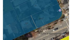
Re-developing the Lawrence Station (70 acres) and Tasman East areas (45 acres) as higher-density* residential neighborhoods, during 2015 to 2025, has been in Santa Clara’s 2010 General Plan (GP) since its adoption by City Council on Nov. 16, 2010.
The GP, which also articulates Santa Clara’s development principles, requirements and goals, has been available on the City’s website for five years.
Every point made in the Council’s discussion is discussed in the GP – overcrowding, losing the industrial tax base, disappearing affordable housing, mass transit-oriented housing, walkable communities. Similar discussions are repeated every time a development project is on the agenda – which, recently, is almost every week.
If the Council wants to change the plan – for example, by slowing development – then put it on the agenda and vote on it. Certainly, much has changed since 2010 to justify an overhaul – especially dissolution of the city’s redevelopment agency, the funding source for many affordable housing projects.
In December, the City kicked off the Lawrence Station project, approving a contract with TKL Associates to develop the detailed master plan and the required Environmental Impact Report (EIR). No specific development proposals for these areas have been brought forward; except for Irvine’s Monticello residential development, part of the larger Lawrence Station area plan.
The plans for both Tasman East and Lawrence Station include “higher-density residential and mixed-use neighborhoods with a full complement of supportive services. Careful planning … is essential to ensure … adequate infrastructure and services, an appropriate interface with surrounding development and access to transit, open space and recreation,” according to the Plan.

Further, the Lawrence Station plan is a joint plan with Sunnyvale “to identify opportunities for higher-density residential and office development near the station; add neighborhood commercial services to serve existing and future residents; and improve access to the station, including enhanced signage and circulation for pedestrians, bicyclists and motorists.”
Over the next year, there will be at least four community meetings to share the progress of the Lawrence Station plan and get input from the community. In March, the Vision plan will come to the Council; in May, an analysis of alternatives; in July, the preferred development plan; in September, a final plan. The draft EIR will be available in the fall, and the Council hopes to approve the final EIR by the end of the year.
The 2010 GP calls for a total of 13,200 new housing units to be built between 2010 and 2035. “Future Focus Areas are located north of the Caltrain corridor, adjacent to existing transit hubs or along major transportation corridors,” according to the GP, and “new residential neighborhoods north of the Caltrain corridor to capitalize on existing transit near the Caltrain Station at Lawrence Expressway and adjacent to the Tasman light rail corridor.”
Current Development Plans Not Unprecedented
The current residential building boom isn’t the first the city has seen. About 19,300 of the Santa Clara’s roughly 45,000 housing units were built between 1950 and 1969, and 11,500 between 1970 and 1989 according to the US Census’ Bureau’s American Community Survey. More than 25 percent of City housing units were built between 1950 and 1959 alone. That wave of development changed farmland into islands of car-centric suburban housing tracts and low-rise industrial and office buildings.
Today’s development wave will convert aging, underutilized industrial tracts into new residential neighborhoods that aren’t automobile-dependent, are designed to optimize delivery of public services delivery, and integrate into the larger community.
*High density residential, defined by the GP is 37 to 50 units/acre, medium density is 19 to 26 units/acre, that is typically built next to major transportation corridors, mass transit and “having an urban feel, with mid-rise buildings, structured or below-grade parking, and shared open space.”


0 comments